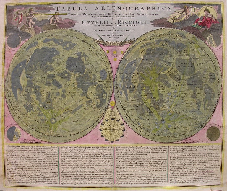
Tabula Selenographica in qua Lunarium Macularum exacta Descriptio secundum Nomenclaturam Praestantissimorum Astronomorum tam Hevelii quam Riccioli Curiosis Rei Sidereae Cultoribus exhibetur Joh. Babr. Doppelmajero Math. P.P. upera Joh. Baptistae Homanni Norinbergae. Undated 1707 or 1742
GORGEOUS HAND-COLORED EARLY 18th c. DOUBLE HEMISPHERE MAP OF THE SURFACE OF THE MOON – based upon the models of Johannes Hevelius and Giovanni Riccioli, this map is the first comparative chart of the Moon. Both spheres illustrate the same side of the Moon and each is topographically detailed, offering a greater than 360 degree viewing with all visible features weighted equally. The left hand map is by Hevelius with place names rendered in his nomenclature; the right hand map is by Riccioli with place names rendered in his nomenclature. Though the two systems of naming would go on to compete with each other for another 140 years, eventually Hevelius’ Latin names gave way to those of Riccioli’s (and those names remain in use today).
The map measures a full 20.5 x 23.5 inches (52.07 x 59.69cm) and first appeared in 1707 in Johann Baptist Homann’s Neuer Atlas, then again in 1742 as plate no. 11 in Doppelmayr’s important Atlas Coelestis. Because both were published by Homann’s Nuremburg firm, there is literally no discernible difference between the two publications; this fact makes it all but impossible to discern which of the two publications this map originated within.
The lunar map on the left, “composed by Hevelius is considered a foundational map in the science of Selenography – or lunar cartography. This map first appeared in Hevelius’ 1647 work Selenographia, [a work which] laid the groundwork for most subsequent lunar cartographic studies. Here the moon is presented as it can never be seen from Earth, at greater than 360 degrees and with all visible features given equal weight. In this map Hevelius also establishes the convention of mapping the lunar surface as if illuminated from a single source – in this case morning light. The naming conventions he set forth, which associate lunar features with terrestrial locations such as ‘Asia Minor’, ‘Persia’, [and ‘Sicilia’, were popular until the middle of the 18th century when Riccioli’s nomenclature took precedence.
“The Riccioli map, on the right, is more properly known as the Riccioli-Grimaldi map, for fellow Jesuit Francesco Grimaldi with whom Riccioli composed the chart. This map first appeared in Riccioli and Grimaldi’s 1651 Almagestum Novum. This was a significant lunar chart and offered an entirely new nomenclature which, for the most part, is still in use today. Curiously, though Riccioli, as a devout Jesuit, composed several treatises denouncing Copernican theory, he chose to name one of the Moon’s most notable features after the astronomer – perhaps suggesting that he was a secret Copernicus sympathizer? Other well-known lunar features named by Riccioli include the Sea of Tranquility where Apollo 11 landed and where Neil Armstrong became the first human to set foot on the moon’s surface.
“The upper left and right hand quadrants feature decorative allegorical cartouche work that include images of angelic children looking through a telescope and a representation of the ancient Greek Moon goddess Selene. Additional mini-maps show the moon in various phases of its monthly cycle” (Geographicus Rare Antique Maps). Beneath the maps is an “extensive Latin text discussing Selenography” (ibid). Between the two spheres appears a model depicting the varied phases of the moon; as well, the variant lunar phases appear in the four corners of the map.
Johannes Hevelius (1611-1687) was a Polish politician (mayor), brewer, and astronomer. Johann Gabriel Doppelmayr (1677-1750) was a German mathematician and astronomer. Giovanni Battista Riccioli (1598-1671) was an Italian Jesuit priest and astronomer. Johann Homann (1664-1724) was a German geographer and cartographer who in 1702 founded the publishing house which published the 1707 map; Homann’s heirs published the 1742 one. Item #599
CONDITIONS & DETAILS: 20.5 x 23.5 inches (52.07 x 59.69cm). Hand-colored with strong printer impression. Small professionally rendered repair on the rear; very small closed tear at the right foot (not impacting image or text); slight toning and a light, barely visible water stain at the upper right corner. The coloring remains bright and vibrant. Very good condition.
Price: $1,000.00